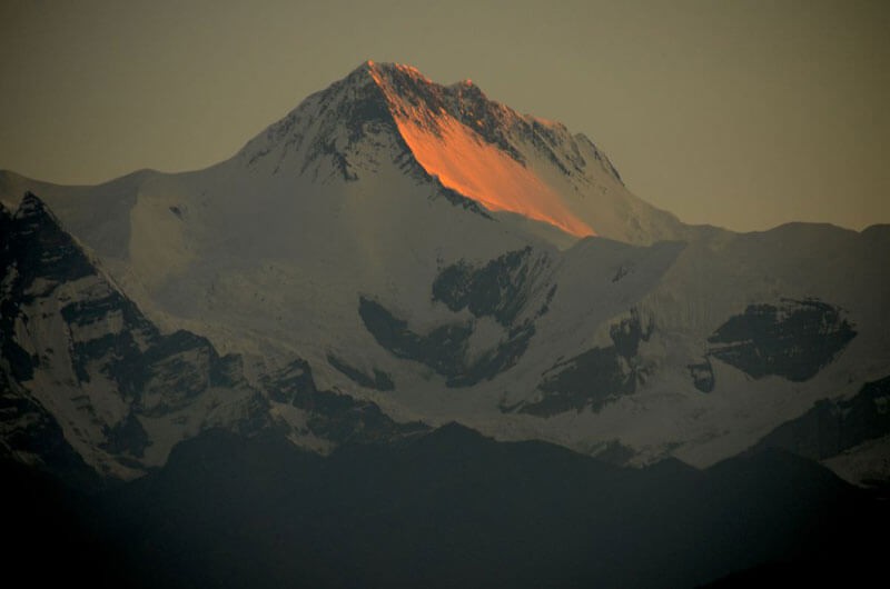
The world’s eight highest mountains are in Nepal
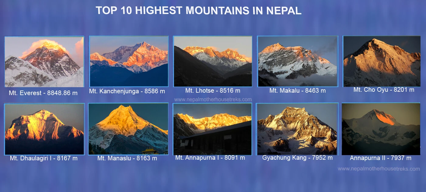
Mt. Everest (8848.86m/29031ft) is the highest mountain in Nepal and the world. Following Everest is Mt. Kanchenjunga at a height of 8586 m (28169 ft) above sea level, which is also the third-highest mountain globally and the second-highest in Nepal. Lhotse (8516 m/27940 ft), Makalu (8485 m/27838 ft), and Cho Oyu (8188 m/26864 ft) are the 4th, 5th, and 6th highest mountains in the world that reside in Nepal. Dhaulagiri I (8167 m/26795 ft) is the 7th highest, and Manaslu (8163m/26781ft) is the 8th highest mountain. The 10th-highest peak in the world, above the height of 8000 m, is Annapurna I, which stands at 8091 m (26545 ft) above sea level.
How many mountains are above 8,000 meters in Nepal?
On the list of the highest mountains in Nepal, there are eight mountains above 8000 m. These eight highest peaks include Everest, Kanchenjunga, Lhotse, Makalu, Cho Oyu, Dhaulagiri I, Manaslu, and Annapurna I.
How Many Mountains Are There In Nepal?
There are 1310 mountains in Nepal. Among these , 326 peaks are open for climbing. The eight highest mountains in Nepal all fall in a height range of above 8000 m.
Highest Peak in the World
Mt. Everest stands tall at 8848.86 m above sea level as the highest peak in the world. Nepal's southeastern ridge spreads across Nepal's border and the Tibetan Autonomous Region (TAR). Out of the top 10 highest mountains in the world, 8 are located in Nepal.
Top 10 Highest Mountains in Nepal with Location
The list of the top 10 highest mountains in Nepal and their locations is as below:
| S.N. |
Mountain |
Height |
Country |
Location |
Section |
First to the Summit (Nationality) |
Date |
| Meters |
Feet |
| 1 |
Mount Everest |
8848.86 |
29,031.69 |
Nepal, China |
Solukhumbu District, Province 1, Nepal |
Mahalangur Himalayan Range |
Edmund Hillary (New Zealander, UK), Tenzing Norgay (Nepalese) |
May 29, 1953 |
| 2 |
Kanchenjunga |
8586 |
28,169 |
Nepal, India |
Taplejung District, Nepal |
Kanchenjunga Himalayan Range |
G. Band, J. Brown, N. Hardie, S. Streather (UK) |
May 25, 1955 |
| 3 |
Lhotse |
8516 m |
27,940 |
Nepal, China |
Khumbu, Province 1, Nepal |
Mahalangur Himalayan Range |
F. Luchsinger, E. Reiss (Swiss) |
May 18, 1956 |
| 4 |
Makalu |
8485 m |
27,838 |
Nepal, China |
Khumbu, Province 1, Nepal |
Makalu Mahalangur Himalayan Range |
J. Couzy, L. Terray, J. Franco, G. Magnone-Gialtsen, J. Bouier, S. Coupé, P. Leroux, and A. Vialatte (French) |
May 15, 1955 |
| 5 |
Cho Oyu |
8188 |
26,864 |
Nepal, China |
Province 1, Nepal |
Mahalangur Himalayan Range |
H. Tichy, S. Jöchler (Austrian), Pasang Dawa Lama |
Oct. 19, 1954 |
| 6 |
Dhaulagiri I |
8163 |
26,795 |
Nepal |
Gandaki Province, Nepal |
Dhaulagiri Himalayan range in Annapurna Region |
A. Schelbert, E. Forrer, K. Diemberger, P. Diener (Swiss), Nyima Dorji, Nawang Dorji (Nepalese) |
May 13, 1960 |
| 7 |
Manaslu |
8163 |
26,781 |
Nepal |
Gorkha, Gandaki Province, Nepal |
Mansiri Himalayan Range |
T. Imamishi, K. Kato, M. Higeta (Japanese), and G. Norbu (Nepalese) |
May 9, 1956 |
| 8 |
Annapurna I |
8091 |
26,545 |
Nepal |
Gandaki Province, Nepal |
Annapurna Himalayan Region |
M. Herzog, L. Lachenal (French) |
June 3, 1950 |
| 9 |
Gyachung Kang |
7952 |
26,089 |
Nepal, China |
Solukhumbu District, Province 1, Nepal |
Mahalangur Himalayan Range |
Pasang Phutar Sherpa, Yukihiko Kato, and Kiyoto Sakaizawa |
April 10, 1964 |
| 10 |
Annapurna II |
7937 |
26,040 |
Nepal |
Gandaki Province, Nepal |
Annapurna Himalayan Region |
Chris Bonington, J. O. M. Roberts, Richard Grant, and Sherpa Ang Nyima |
May 17, 1960 |
Top 10 Highest Mountains in Nepal
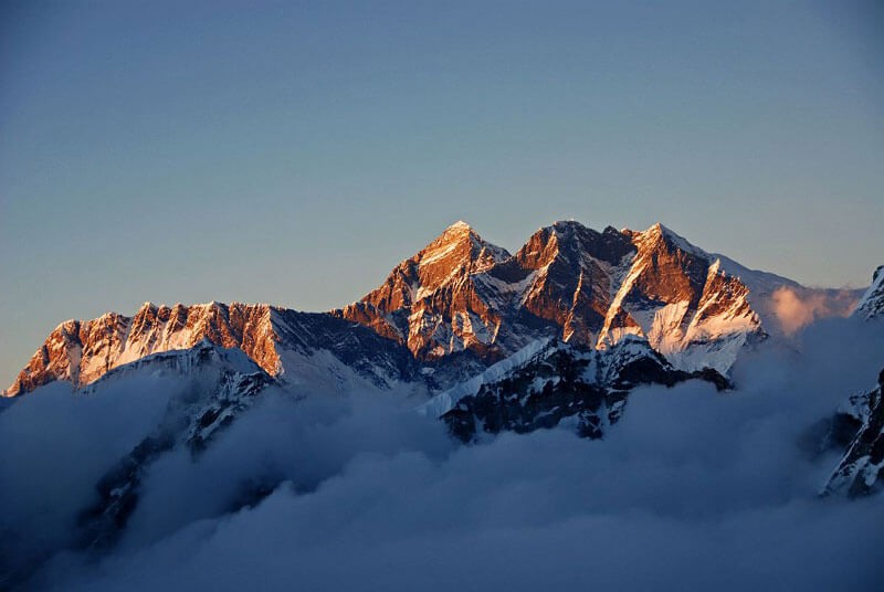
Here is a list of the ten highest mountains in Nepal you must see in your lifetime, including the world’s eighth-highest mountain. Mt. Sagarmatha, also known over the world as Mt. Everest, is the tallest mountain in Nepal. It lies in the Sagarmatha Mountain region in the southern part of Nepal. Its current height reportedly is 8848.86 m above sea level.
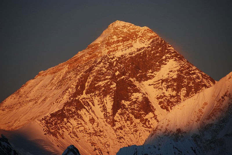
Mt. Everest (8,848.86)—the highest Mountain in the World
Elevation: m/29,029 ft
Location: Mahalangur Himalayan Range in the Khumbu region
Coordinates: 27°59′17″N 86°55′31″E
First summiteers: Sir Edmund Hillary and Tenzing Norgay Sherpa on 29 May 1953
Position in the World: 1st
Position in Nepal: 1st
Fifty-five million years ago, the Indian subcontinent collided with Eurasia, creating a stunning elevation that we now know to be the world's highest peak. Mt. Everest is the name of the highest peak, which stands at an elevation of 8848.86 m. Sagarmatha is the name most Nepali people know, which means "goddess of the sky." Its Tibetan name is Chomolungma, which translates to "Holy Mother Peak." It resides in Nepal's southeastern part, on the border of Nepal and the Tibetan Autonomous Region.
The first people to officially summit Everest were Tenzing Norgay Sherpa and Edmund Hillary in 1953. The Everest Base Camp Trek, the Gokyo Chola Pass Trek, the Everest Three Passes Trek, and the Everest Base Camp Trek by Helicopter in the Everest Region are among the most popular treks in the Everest Region. These treks garner popularity because of the spectacular panoramic view of the mountains and the gentle ravines, rich ecosystems, exquisite Sherpa settlements, and ancient monasteries.
A Brief Climbing History of Mount Everest
Sir Edmund Hillary and Tenzing Norgay Sherpa had set out on an epic journey to the top of the world on 29 May 1953. However, an unsuccessful attempt was made in 1921 from the Tibetan side because Nepal was still closed off to foreigners.
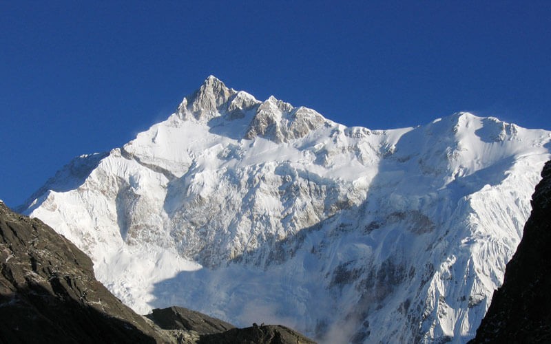
Kanchenjunga (8,586 m), the Five Treasures of the Snow
Elevation: m/28,169 ft
Location: Taplejung District. Part of the Northern Kanchenjunga Himalayan range
Coordinates: 27°42′12″N 88°08′51″E
First summiteers: George Band and Joe Brown on May 25, 1955
Location: Mahalangur Himalayan Range in the Khumbu region
Position in the World: 3rd
Position in Nepal: 2nd
From 1838 to 1849, when Mt. Everest was still unknown to the world, the world's highest peak was considered Mt. Kanchenjunga. It stands tall as the 2nd-highest peak in Nepal and the 3rd-highest peak in the world. It lies on the Nepal and Sikkim (India) border, and three of the four routes to Kanchenjunga are in Nepal.
The first two people to officially conquer the challenging ascent of Kanchenjunga were Joe Brown and George Band on the 25th of May 1995. The unique ecosystem that survives in this region falls under 14 different protected areas. Several rare wild animals, like Snow Leopards, Asian black bears, red pandas, blood pheasants, and much more, live in these preservation areas.
The Kanchenjunga Circuit Trek and Sele La Pass Trek are two of the most popular treks in the Kanchenjunga region. The thrilling journey is the beauty of the Kanchenjunga Conservation Area and eastern Nepal's most rural settlements' challenging lifestyle.
Brief Climbing History of Kanchenjunga
Joe Brown and George officially climbed Mount Kanchenjunga on May 25, 1955, with Charles Evans serving as their trek leader from Nepal's side. The local Limbu people of Nepal believe, as legends say, that the mountain is the abode of the supreme Goddess Yuma Sammang; it was forbidden to climb before Joe and George. Similarly, the Tibetan people believe this valley is named Beyul Demoshong.
Lhotse (8,516 m)—The Wall of Mountains
Elevation: 8,516 m/27,940
Location: Mahalangur Himalayan range and the Everest massif of the Khumbu region
Coordinates: 27°57′42″N 86°55′59″E
First summiteers: Ernst Reiss and Fritz Luchsinger on May 18, 1956
Position in the World: 4th
Position in Nepal: 3rd
Lhotse is Nepal’s third and the world’s fourth-highest peak. As the 3rd highest mountain in Nepal, its recorded height is 8516 m above sea level. The name "Lhotse" in the Tibetan language translates to "South Peak." As a part of the Everest Massif, the peak of Lhotse connects with Mt. Everest via the South Col (a vertical ridge), which is why it is often confused with the south peak of Everest. It also contains three prominent peaks: the main peak (8516 m), Lhotse East (8418 m), and Lhotse Shar (8383 m). The towering peak resides on the border of Nepal and Tibet.
The Gokyo Chola Pass Trek provides one of the best viewpoints of Lhotse. The Everest Three Passes Trek and the Everest Base Camp Trek by Helicopter also provide an eye-catching view of the stunning Lhotse, including the other highest mountains in Nepal.
Brief climbing history of Lhotse
The summit of Lhotse remained unnoticed until the ascent of Everest. The first successful ascent to Lhotse was on the 18th of May 1956 by two Swiss climbers, Ernst Reiss and Fritz Luchsinger. After that, many climbers attempt to climb Lhotse from diverse routes.
Makalu (8,485, The Himalayan Pyramid)
Elevation: 8,463 m/27,766 ft
Location: Makalu Mahalangur Himalayan range in the Khumbu region
Coordinates: 27°53′23″N 87°05′20″E
First summiteers: Lionel Terray and Jean Couzy on May 15, 1955
Position in the World: 5th
Position in Nepal: 4th
With a stunning height of 8485 m, it is the fifth-highest peak on planet Earth. The striking pyramid structure of Makalu, with sharp ridges on all four sides, makes it one of the most beautiful mountains in Nepal. It is also one of the most dangerous climbs because of these sharp knife-edge ridges. The name Makalu comes from the Sanskrit word "Maha Kala," a name used to denote the Hindu deity Shiva.
One of the most beautiful highlights of Makalu is the Makalu Barun Valley at the base of Mt. Makalu. The valley is donned with countless gentle white rivers and stunning glaciers. The Makalu Barun National Park accommodates a diverse topography ranging from lush forests to snow-covered mountains. It is also home to countless endangered animals like snow leopards, lynx, red pandas, Himalayan tahr, etc.
The Makalu Base Camp Trek is one of Nepal's most isolated yet beautiful treks, with a jaw-dropping view of Makalu. The Sherpani Coal Trek is also another of the thrilling treks within the Makalu Region. The Makalu region also hosts other off-the-beaten-path trekking trails where trekkers can enjoy themselves in seclusion away from the packed routes.
Brief Climbing History of Mt. Makalu
The first people to reach the top of Makalu were Lionel Terray and Jean Couzy on the 15th of May 1955. Just one day after the official ascent, Jean Franco, accompanied by Guido Magnone and Gyalzen Norbu Sherpa, successfully summited Makalu. However, an American team under Riley Keegan's leadership attempted the southeast ridge in the spring of 1954 but regrettably turned back at 7,100 meters (23,300 feet) due to an endless barrage of storms. Likewise, a team from New Zealand, including Sir Edmund Hillary, also attempted fruitlessly in the same spring, even with injury and illness.
Cho Oyu (8,188 m): The Turquoise Goddess
Elevation: 8,188 meters (26,864 ft).
Location: Mahalangur Himalayan Range in the Khumbu region
Coordinates: 28°05′39″N 86°39′39″E
First summiteers: Pasang Dawa Lama, Herbert Tichy, and Joseph Jöchler on October 19, 1954
Position in the World: 6th
Position in Nepal: 5th
In the Khumbu sub-section of Mahalangur Himalaya, 20 km west of Mt. Everest, lies Cho Oyu. It is the fifth-highest mountain in Nepal and the sixth-highest in the world. It lies 8188 m above sea level in the eastern part of Nepal. It is one of the easier climbs on the list of the highest mountains in Nepal.
On the 19th of October, 1954, Herbert Tichy, Joseph Jӧchler, and Sherpa Pasang Dawa Lama became the first people to step foot on Cho Oyu. Among the other successful summits at 8000 meters, Cho Oyu was the fifth.
One of the highlights of Cho Oyu is the beautiful Nangpa La, a glacier pass of 19000-foot height. The pass is why the ascent to Cho Oyu is one of the easiest of the others.
The Gokyo Lakes Trek falls in the BBC list of "50 places to go before you die." It provides one of the most enigmatic and picturesque views of Cho Oyu, along with other Khumbu giants.
Brief Climbing History of Cho Oyu
Cho Oyu is considered the easiest eight-thousand-meter peak with the lowest death-summit ratio. This is the second most climbed eight-thousand-meter mountain after Mt. Everest. Cho Oyu was the first attempt by Eric Shipton and included Edmund Hillary, Tom Bourdillon, and George Lowe, an expedition organized and financed by the Joint Himalayan Committee of Great Britain in 1952.
But they return from 6,650 m (21,820 ft) elevation due to technical complications and avalanche hazards at an ice cliff. An Austrian expedition team of Herbert Tichy, Joseph Jöchler, and Pasang Dawa Lama Sherpa first climbed on October 19, 1954, via the northwest ridge.
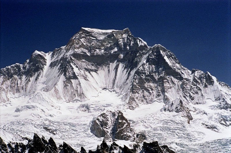
Dhaulagiri I (8,167)—The Shining White Mountain
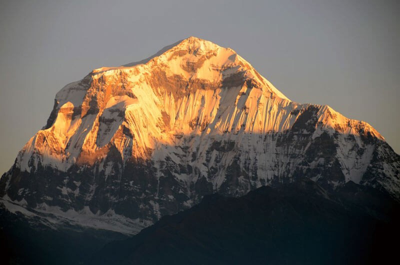
Elevation: 8,167 m/26,795 ft
Height: 8,167 meters
Location: Dhaulagiri Himalayan range in the Annapurna region
Coordinates: 28°41′48″N 83°29′35″E
First summiteers: Kurt Diemberger, A. Schelbert, E. Forrer, Nawang Dorje, and Nyima Dorje on May 19, 1960
Position in the World: 7th
Position in Nepal: 6th
Dhaulagiri I, the seventh (7th) highest peak globally, lies entirely in Nepal at 8,167 m from sea level. It is the 6th highest mountain peak in Nepal, located in the north-central part of Nepal. The name Dhaulagiri comes from Sanskrit. "Dhawla" means "white and dazzling," and "Giri" means "mountain." The highest point is Dhaulagiri I.
The stunning Kali Gandaki Gorge, the world’s deepest gorge, forms in the middle of Dhaulagiri I and Annapurna I, which lie 35 km apart. The location of Dhaulagiri makes it responsible for casting a rain shadow in Mustang and Dolpo, which has created a wild, semi-desert-like landscape in these areas.
The most popular trek in the Dhaulagiri Region, which perfectly captures its beauty, is the Dhaulagiri Circuit Trek. Poon Hill Trek is also one of the more sought-after short treks with a captivating view of Dhaulagiri Massif.
Brief Climbing History of Dhaulagiri Himal
Dhaulagiri I was first attempted in 1950 by a French expedition team led by Maurice Herzog. But their attempt was unsuccessful due to a feasible route to the top, and they switched to Annapurna. The first ascent to Dhaulagiri was on the 13th of May 1960 by Kurt Diemberger, Ernst Forrer, Albin Schelbert, Nyima Dorje Sherpa, and Nawang Dorje Sherpa.
Manaslu (8,163)—The Mountain of Spirits
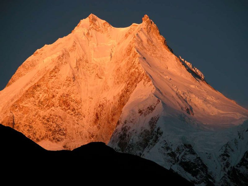
Elevation: m/26,759 ft
Location: Gorkha, Part of the Mansiri Himalayan range
Coordinates: 28°33′00″N 84°33′35″E
First ascenders: Artur Hajzer, Gyalzen Norbu, and Toshio Imanishi on May 9, 1956
Position in the World: 8th
Position in Nepal: 7th
With a stunning height of 8163 m, Manaslu is the eighth-highest peak in the world. It is also the highest peak of the Gorkha massif. It is one of the highest peaks, more than 8000 m, after Dhaulagiri, which lies completely in Nepal. The name Manaslu comes from Sanskrit, which translates to “Mountain of spirits." Long mountain ridges and valleys of glaciers surround the mountain, making it approachable from all directions.
The Manaslu Circuit Trek and Tsum Valley Trek are some of the most sought-after isolated treks with a breathtaking bird's-eye view of Manaslu, among many other mountains. The Manaslu Circuit Trek passes through the spectacular Larkya La Pass. Tsum Valley is also a sacred valley for people following Buddhism, so the trek is a spiritual experience if nothing else.
Brief Climbing History of Mt. Manaslu
The first ascent to Manaslu was successful on the 9th of May 1956 by Toshio Imanishi and Gyaltsen Norbu. Aritsune Maki was the one who led this all-female Japanese expedition. After this, numerous fruitful attempts from different paths were able to reach the top of the Manaslu. During the COVID-19 period, Bahrain Prince Mohamed Hamad Mohamed Al Khalifa successfully scaled the peak in October 2020 with 13 members of his expedition team and 43 Sherpa experts.
Annapurna I (8091—The Goddess of the Harvest)
Elevation: 8091 m/26,545 ft
Location: Part of the Annapurna massif in the Annapurna region.
Coordinates: 28°35′44″N 83°49′13″E
First summiteers: Maurice Herzog, Louis Lachenal, and Lionel Terray on June 3, 1950
Position in the World: 10th
Position in Nepal: 8th
Annapurna I, the tenth (10th) highest peak globally, gets its name from a Hindu goddess of food and grains. In Sanskrit, the word 'Anna' means food, and 'Purna’ means full. It was the first-ever peak over 8000 m to be successfully summited. Annapurna is located in the north-central part of Nepal. It is generally recognized as two separate peaks, Annapurna I and Annapurna II, which are Annapurna Massif's highest points.
The spectacular Annapurna region collects one-third of the foreign travelers to Nepal every year. The Annapurna Base Camp Trek is the most sought-after trek in Nepal, with Annapurna Massif's best view among the other treks. Other popular treks include ABC Trek via Poon Hill Trek, Poon Hill Trek, and Annapurna Short Trek.
Brief Climbing History of Annapurna I
Annapurna I was the first 8000-meter mountain with a successful ascent. The first successful ascent was on the 3rd of June 1950 by Maurice Herzog and Louis Lachenal. It remained the highest ascent for three years until the first successful climb to Everest.
Gyachung Kang (7,952 m)
Elevation: 7,952 m/26,089 ft
Location: Khumbu. Part of the Mahalangur Himalayan range
Coordinates: 28°05′53″N 86°44′42″E
First ascenders: Pasang Phutar Sherpa, Yukihiko Kato, and Kiyoto Sakaizawa on April 10, 1964
Position in the World: 15th
Position in Nepal: 9th
The fifteenth-highest peak in the world, Gyachung Kang, lies in the Mahalangur Himal section of the Himalayas, between two giant massifs: Cho Oyu (8,201 m) and the top of the world, Mount Everest (8,848.86 m), bordering China and Nepal.
Gyachung Kang is the highest peak below eight thousand meters; therefore, it is far less renowned than the lowest of the eight-thousand, which is only about 100 m (328 ft) higher.
A Brief Climbing History of Gyachung Kang
A Japanese expedition team of Y. Kato, K. Sakaizawa, Pasang Phutar, and, on the next day, K. Machida and K. Yasuhisa first ascended the Gyachung Kang on April 10, 1964.
Annapurna II (7,937 m)
Elevation: m/26,040 ft
Location: Part of the Annapurna massif in the Annapurna region.
Coordinates: 28°32′05″N 84°07′19″E
First summiteers: Chris Bonington, J. O. M. Roberts, Richard Grant, and Sherpa Ang Nyima in 1960
Position in the World: 16th
Position in Nepal: 10th
The tenth-highest mountain in Nepal, Annapurna II (7,937 m), is the eastern anchor of the Annapurna Mountain Range near the beautiful city of Pokhara. This is the second-highest peak among the five series of the Annapurna Range. Annapurna II is in 16th position among the highest peaks in the world. Both the lakeside city of Pokhara and the popular Dhampus-Sarangkot Trek offer a wonderful view of Mount Annapurna II.
Brief Climbing History of Annapurna II
On May 17, 1960, a British, Indian, and Nepalese team under the direction of J. O. M. Roberts and including Richard Grant, Chris Bonington, and Sherpa Ang Nyima approached Annapurna II from the north.
Conclusion
Nepal is a paradise for mountaineers all over the world, as the land of the Himalayas. The world's eight highest mountains all reside in Nepal. Following these highest mountains in Nepal is also the diverse landscape that accommodates various flora and fauna. When combined with the mountains' rich and untouched culture, visiting these Himalayan wonders becomes unforgettable. You must travel to Nepal at least once in your lifetime if you want to set foot where very few others have.